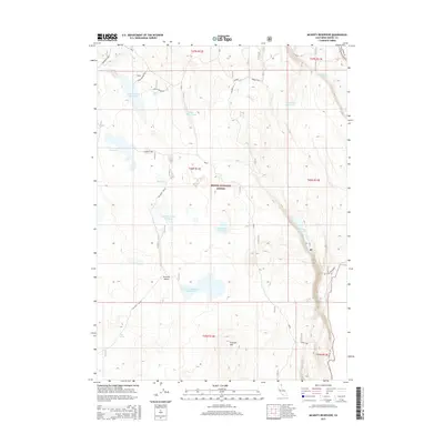
2015 Map of McGinty Reservoir
USGS Topo · Published 2015About this map
The high plateau landscape of Modoc National Forest is defined here by a series of high-altitude water management features and seasonal basins. Notable water bodies including McGinty Reservoir, Lakeshore Reservoir, and the broad basin of Mud Lake speak to the region's ranching and conservation history. The geography is anchored by the prominent Crowder Mountain in the south, overlooking the Rimrock Valley and its namesake Rimrock Valley Reservoir. A network of unpaved forest roads like Pencil, Garden, and Rim Rock Valley thread through the terrain, connecting essential livestock and wildlife infrastructure such as Drift Fence Tank and Green Spring Reservoir. This map documents a specialized landscape within Modoc County where water catchment and forest management intersect across the high California interior.
Find a feature on this map
31 named features on this map. Tap any name to fly to it.
Don’t see what you’re looking for? This feature index may not catch every label — zoom into the map to look around manually.
Map Details
Editions of this 2015 McGinty Reservoir Map
This is the sole edition of this map. No revisions or reprints were ever made.
Other maps of this area
1886 · Alturas
USGS Topo · 1:250,000
1892 · Alturas
USGS Topo · 1:250,000
1954 · Alturas
USGS Topo · 1:250,000
1958 · Alturas
USGS Topo · 1:250,000
1962 · Alturas
USGS Topo · 1:250,000
1962 · Davis Creek
USGS Topo · 1:62,500
1962 · Big Sage Reservoir
USGS Topo · 1:62,500
1962 · Willow Ranch
USGS Topo · 1:62,500
1962 · South Mountain
USGS Topo · 1:62,500
1965 · Alturas
USGS Topo · 1:250,000