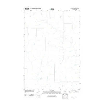
2012 Map of McIntosh SW
USGS Topo · Published 2012About this map
Hump Cr meanders through the northern reaches of this rural Corson County landscape, illustrating the remote prairie drainage systems of the Rock Creek District. The terrain is defined by its subtle watercourses, where Little Soldier Cr and Soldier Cr flow through an open expanse largely uninterrupted by dense settlement. The transportation network is sparse, consisting of foundational section-line roads like 236th Ave and 107th St, which provide the primary access to the vast agricultural allotments in this part of South Dakota. This 2012 survey reveals the persistent reliance on original land-office survey lines for modern infrastructure, where the minimal road grid follows the precise cardinal directions established over a century prior. The concentration of small ponds and intermittent stream beds suggests a landscape meticulously mapped for its hydrological importance to local ranching and land management.
Find a feature on this map
5 named features on this map. Tap any name to fly to it.
Don’t see what you’re looking for? This feature index may not catch every label — zoom into the map to look around manually.
Map Details
Editions of this 2012 McIntosh SW Map
This is the sole edition of this map. No revisions or reprints were ever made.
Other maps of this area

1953 · McIntosh
USGS Topo · 1:250,000

1956 · Black Horse NE
USGS Topo · 1:24,000

1956 · Cottonwood Creek NE
USGS Topo · 1:24,000

1956 · Black Horse
USGS Topo · 1:24,000

1958 · McIntosh
USGS Topo · 1:250,000

1972 · McIntosh SW
USGS Topo · 1:24,000

1972 · Morristown SE
USGS Topo · 1:24,000

1972 · Watauga
USGS Topo · 1:24,000

1972 · Hump Butte
USGS Topo · 1:24,000
1972 · McIntosh SE
USGS Topo · 1:24,000