
1956 Map of Black Horse NE
USGS Topo · Published 1957About this map
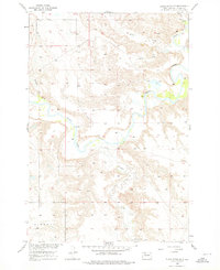
Grand River meanders through this portion of Corson County during the mid-1950s, a period when the Department of the Interior was focused on the development of the Missouri River Basin. The landscape is defined by the winding paths of several tributaries, including Firesteel Creek, Soldier Creek, and White Shirt Cr. In the southern reaches of the map, the community life is anchored by the Holy Spirit Ch and an adjacent Cem, providing a window into the rural settlements within the Liberty boundary. A prominent topographical feature known as the Hump stands out in the northern section, overlooking the river valley. This survey reflects the post-war efforts to document the topography and water resources of South Dakota, providing precise elevation data and land use patterns of the era.
Find a feature on this map
8 named features on this map. Tap any name to fly to it.
Don’t see what you’re looking for? This feature index may not catch every label — zoom into the map to look around manually.
Map Details
Editions of this 1956 Black Horse NE Map
3 editions found
Other maps of this area

1953 · McIntosh
USGS Topo · 1:250,000

1956 · Miscol SW
USGS Topo · 1:24,000

1956 · Black Horse SW
USGS Topo · 1:24,000

1956 · Black Horse SE
USGS Topo · 1:24,000

1956 · Black Horse
USGS Topo · 1:24,000

1956 · Miscol
USGS Topo · 1:24,000

1956 · Bullhead SW
USGS Topo · 1:24,000

1958 · McIntosh
USGS Topo · 1:250,000

1972 · McIntosh SW
USGS Topo · 1:24,000
1972 · McIntosh SE
USGS Topo · 1:24,000