
1956 Map of Miscol
USGS Topo · Published 1957About this map
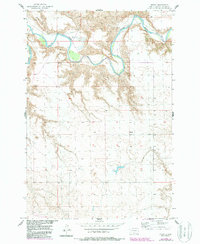
The Grand River winds through the northern portion of this South Dakota landscape, creating sharp meanders and deep erosion patterns in the river valley. In the mid-1950s, the small settlement of Miscol sat atop the higher plateau south of the river, serving as a focal point for the surrounding rural area of Corson County. This survey was conducted as part of a Department of the Interior program for the development of the Missouri River Basin, documenting the drainage and topography of this river system. To the northwest, Brown Ch and a marked Ford across the river indicate the early infrastructure of this prairie community. The terrain is characterized by intricate coulees and breaks that descend from the high plains toward the riverbed, illustrating the dramatic geography of the northern plains before significant modern alteration.
Find a feature on this map
7 named features on this map. Tap any name to fly to it.
Don’t see what you’re looking for? This feature index may not catch every label — zoom into the map to look around manually.
Map Details
Editions of this 1956 Miscol Map
2 editions found
Other maps of this area

1953 · McIntosh
USGS Topo · 1:250,000

1956 · Miscol SW
USGS Topo · 1:24,000

1956 · Black Horse NE
USGS Topo · 1:24,000

1956 · Bullhead
USGS Topo · 1:24,000

1956 · Black Horse SE
USGS Topo · 1:24,000

1956 · Miscol SE
USGS Topo · 1:24,000

1956 · Bullhead SW
USGS Topo · 1:24,000

1956 · Miscol NE
USGS Topo · 1:24,000

1958 · McIntosh
USGS Topo · 1:250,000
1972 · McIntosh SE
USGS Topo · 1:24,000