
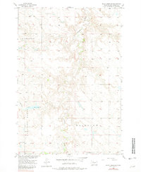
1956 Map of Black Horse SE
USGS Topo · Published 1957About this map
Firesteel Creek meanders through the central and northern reaches of this landscape, a defining drainage feature in Corson County. The mid-1950s terrain is marked by broad upland plateaus and distinct geographical divisions such as Liberty, Fairview, and the prominent Pleasant Ridge to the west. This survey, conducted as part of the Department of the Interior program for the development of the Missouri River Basin, documents a rural infrastructure centered on education and small-scale water management. Distributed across the townships are several rural schoolhouses, including Liberty Sch in the northwest and Severns Sch and Fitzgerald Sch in the south, reflecting the community structure of the era. The presence of Battle Dam and its associated Standing Cloud Creek drainage illustrates the localized efforts to manage water resources in this part of South Dakota.
Find a feature on this map
10 named features on this map. Tap any name to fly to it.
Don’t see what you’re looking for? This feature index may not catch every label — zoom into the map to look around manually.
Map Details
Editions of this 1956 Black Horse SE Map
2 editions found
Other maps of this area

1953 · McIntosh
USGS Topo · 1:250,000

1956 · Miscol SW
USGS Topo · 1:24,000

1956 · Black Horse NE
USGS Topo · 1:24,000

1956 · Black Horse SW
USGS Topo · 1:24,000

1956 · Black Horse
USGS Topo · 1:24,000

1956 · Miscol
USGS Topo · 1:24,000

1958 · McIntosh
USGS Topo · 1:250,000

1978 · Brewer Butte
USGS Topo · 1:24,000

1978 · Isabel
USGS Topo · 1:24,000
1978 · Firesteel
USGS Topo · 1:24,000