
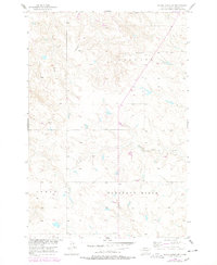
1956 Map of Black Horse SW
USGS Topo · Published 1957About this map
Liberty and Pleasant Ridge townships define this mid-century landscape in Corson County, documented through a Missouri River Basin development survey. The terrain is characterized by the drainages of Louse Creek and Standing Cloud Creek, which carve through the high prairie of North-Central South Dakota. Settlement patterns at this time reflect a rural, community-oriented structure anchored by small country schools. Educational sites like Lightcap Sch, Cedar Sch, and Pleasant View Sch are distributed across the townships, serving the dispersed ranching and farming families of the era. The presence of a Strip Mine in the western portion of the quadrangle suggests the localized extraction of lignite or other resources, a common economic supplement in this region. This survey captures a specific moment in the rural development of the northern plains, illustrating how township lines and small-scale industry organized the land.
Find a feature on this map
10 named features on this map. Tap any name to fly to it.
Don’t see what you’re looking for? This feature index may not catch every label — zoom into the map to look around manually.
Map Details
Editions of this 1956 Black Horse SW Map
2 editions found
Other maps of this area

1953 · McIntosh
USGS Topo · 1:250,000

1956 · Black Horse NE
USGS Topo · 1:24,000

1956 · Cottonwood Creek NE
USGS Topo · 1:24,000

1956 · Black Horse SE
USGS Topo · 1:24,000

1956 · Black Horse
USGS Topo · 1:24,000

1956 · Cottonwood Creek SE
USGS Topo · 1:24,000

1958 · McIntosh
USGS Topo · 1:250,000

1978 · Isabel
USGS Topo · 1:24,000
1978 · Firesteel
USGS Topo · 1:24,000

1980 · McIntosh
USGS Topo · 1:100,000