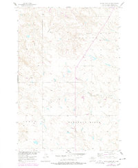
1956 Map of Black Horse SW
USGS Topo · Published 1978About this map
Liberty and Pleasant Ridge characterize this high-plains landscape within the Standing Rock Indian Reservation during the mid-20th century. The mapping reflects a sparsely populated area where education and industry are marked by isolated landmarks like the Lightcap Sch and a local Strip Mine in the western reaches. Drainage patterns are defined by the winding paths of Louise Creek and Standing Cloud Creek, which cut through the high ground. Produced as part of a Department of the Interior program for the development of the Missouri River Basin, the survey captures the transition from 1950s aerial photography to 1970s updates, showing a terrain shaped by both natural watercourses and the early extraction of resources on the reservation.
Find a feature on this map
9 named features on this map. Tap any name to fly to it.
Don’t see what you’re looking for? This feature index may not catch every label — zoom into the map to look around manually.
Map Details
Editions of this 1956 Black Horse SW Map
2 editions found
Other maps of this area

1953 · McIntosh
USGS Topo · 1:250,000

1956 · Black Horse NE
USGS Topo · 1:24,000

1956 · Black Horse SW
USGS Topo · 1:24,000

1956 · Cottonwood Creek NE
USGS Topo · 1:24,000

1956 · Black Horse SE
USGS Topo · 1:24,000

1956 · Black Horse
USGS Topo · 1:24,000

1956 · Cottonwood Creek SE
USGS Topo · 1:24,000

1958 · McIntosh
USGS Topo · 1:250,000

1978 · Isabel
USGS Topo · 1:24,000
1978 · Firesteel
USGS Topo · 1:24,000