
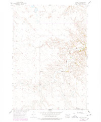
1956 Map of Miscol SE
USGS Topo · Published 1957About this map
High Bank Creek winds through the northern reaches of the Missouri River Basin, defining the drainage of this portion of Corson County during the mid-1950s. The landscape is characterized by its vast upland prairie and the distinct ridges of Little Oak and Freedom. This 1956 field check captures a sparse rural settlement pattern typical of the region's agricultural and ranching history. Two local educational landmarks, Chapel Sch and Long Butte Sch, serve as primary focal points for the scattered population, reflecting the community structure of the time before further consolidation. The topography, mapped from 1950 aerial photography, illustrates a network of unimproved dirt roads connecting isolated farmsteads across the rolling hills of the northern plains.
Find a feature on this map
5 named features on this map. Tap any name to fly to it.
Don’t see what you’re looking for? This feature index may not catch every label — zoom into the map to look around manually.
Map Details
Editions of this 1956 Miscol SE Map
2 editions found
Other maps of this area

1953 · McIntosh
USGS Topo · 1:250,000

1956 · Miscol SW
USGS Topo · 1:24,000

1956 · Little Eagle SW
USGS Topo · 1:24,000

1956 · Little Eagle NW
USGS Topo · 1:24,000

1956 · Miscol
USGS Topo · 1:24,000

1956 · Miscol NE
USGS Topo · 1:24,000

1958 · McIntosh
USGS Topo · 1:250,000

1975 · Glencross
USGS Topo · 1:24,000

1978 · Brewer Butte
USGS Topo · 1:24,000

1978 · Timber Lake
USGS Topo · 1:24,000