
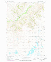
1956 Map of Little Eagle SW
USGS Topo · Published 1957About this map
High Bank Creek winds through the northern breaks of this Corson County landscape, illustrating the intricate drainage patterns of the Missouri River Basin during the mid-1950s. The map captures a rural transition where social centers are clearly marked by the Good Shepherd Ch and the Meyer Sch, both serving the surrounding ranchlands. Further south, the terrain shifts towards Saddle Butte and the waters of Spring Lake. A notable detail for historians is the inclusion of the Spring Lake Sch (Abandoned), which suggests a shift in the local population or school consolidation during this era. The western portion of the quadrangle is defined by the Freedom township boundary, providing a clear spatial context for genealogical and land-use research in this part of South Dakota.
Find a feature on this map
8 named features on this map. Tap any name to fly to it.
Don’t see what you’re looking for? This feature index may not catch every label — zoom into the map to look around manually.
Map Details
Editions of this 1956 Little Eagle SW Map
2 editions found
Other maps of this area

1953 · McIntosh
USGS Topo · 1:250,000

1956 · Little Eagle
USGS Topo · 1:24,000

1956 · Little Eagle SE
USGS Topo · 1:24,000

1956 · Miscol SE
USGS Topo · 1:24,000

1956 · Little Eagle NW
USGS Topo · 1:24,000

1956 · Miscol NE
USGS Topo · 1:24,000

1958 · McIntosh
USGS Topo · 1:250,000

1975 · Glencross
USGS Topo · 1:24,000
1975 · Glencross NE
USGS Topo · 1:24,000

1978 · Timber Lake
USGS Topo · 1:24,000