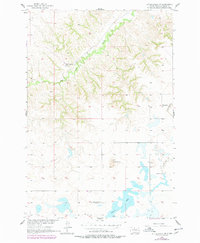
1956 Map of Little Eagle SW
USGS Topo · Published 1978About this map
Spring Lake and its surrounding prairie landscape define this portion of the Standing Rock Indian Reservation as it was documented in the mid-1950s and updated in the 1970s. The map highlights the sparse distribution of rural community centers across the rolling grasslands of Corson County, characterized by small schools and country churches. Key landmarks for local history include the Good Shepherd Ch and the Meyer Sch, which represent the social anchors of this ranching and agricultural region. Significant terrain features such as Saddle Butte and the drainage of High Bank Creek provide a clear view of the natural hydrology and topography. An interesting detail for genealogists and researchers is the note of the Spring Lake Sch (Abandoned), documenting the decline of small school districts in the area during the late twentieth century.
Find a feature on this map
7 named features on this map. Tap any name to fly to it.
Don’t see what you’re looking for? This feature index may not catch every label — zoom into the map to look around manually.
Map Details
Editions of this 1956 Little Eagle SW Map
2 editions found
Other maps of this area

1953 · McIntosh
USGS Topo · 1:250,000

1956 · Little Eagle SW
USGS Topo · 1:24,000

1956 · Little Eagle
USGS Topo · 1:24,000

1956 · Little Eagle SE
USGS Topo · 1:24,000

1956 · Miscol SE
USGS Topo · 1:24,000

1956 · Little Eagle NW
USGS Topo · 1:24,000

1956 · Miscol NE
USGS Topo · 1:24,000

1958 · McIntosh
USGS Topo · 1:250,000

1975 · Glencross
USGS Topo · 1:24,000
1975 · Glencross NE
USGS Topo · 1:24,000