
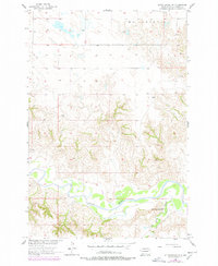
1956 Map of Little Eagle NW
USGS Topo · Published 1957About this map
The Grand River winds through the southern portion of this landscape in Corson County, showing a complex network of sandbars and shifting channels. This 1956 field-checked survey reveals a rural territory defined by its watercourses, where the High Bank Creek joins the main river valley. A notable center of local community life is indicated by the Little Oak Creek Ch, positioned near the confluence of its namesake stream and the river. The presence of a Ford across the river highlights the importance of traditional crossing points in an era of limited infrastructure. To the north, the terrain transitions into the high plains of McLaughlin, while the small settlement or landmark known as Eagle stands as a focal point in the central uplands. This survey was produced as part of the Department of the Interior program for the development of the Missouri River Basin, documenting the topography before significant mid-century changes to the regional watershed.
Find a feature on this map
6 named features on this map. Tap any name to fly to it.
Don’t see what you’re looking for? This feature index may not catch every label — zoom into the map to look around manually.
Map Details
Editions of this 1956 Little Eagle NW Map
2 editions found
Other maps of this area

1953 · McIntosh
USGS Topo · 1:250,000

1956 · Little Eagle SW
USGS Topo · 1:24,000

1956 · Little Eagle
USGS Topo · 1:24,000

1956 · Little Eagle SE
USGS Topo · 1:24,000

1956 · Bullhead
USGS Topo · 1:24,000

1956 · Miscol SE
USGS Topo · 1:24,000

1956 · Miscol NE
USGS Topo · 1:24,000

1958 · McIntosh
USGS Topo · 1:250,000

1966 · McLaughlin
USGS Topo · 1:24,000

1971 · McLaughlin SW
USGS Topo · 1:24,000