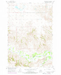
1956 Map of Little Eagle NW
USGS Topo · Published 1978About this map
The Grand River meanders across the southern portion of this 1950s survey, defining the landscape of the Standing Rock Indian Reservation in Corson County. This territory, situated within the McLaughlin district, is characterized by a network of drainage channels and significant elevation changes north of the riverbank. A critical point of community interest is the Little Oak Creek Ch, located near the confluence where High Bank Creek feeds into the primary river valley. These watercourses and the relative placement of the local church provide essential landmarks for understanding the mid-century settlement patterns and land use within this portion of the reservation before late-twentieth-century updates.
Find a feature on this map
7 named features on this map. Tap any name to fly to it.
Don’t see what you’re looking for? This feature index may not catch every label — zoom into the map to look around manually.
Map Details
Editions of this 1956 Little Eagle NW Map
2 editions found
Other maps of this area

1953 · McIntosh
USGS Topo · 1:250,000

1956 · Little Eagle SW
USGS Topo · 1:24,000

1956 · Little Eagle
USGS Topo · 1:24,000

1956 · Little Eagle SE
USGS Topo · 1:24,000

1956 · Bullhead
USGS Topo · 1:24,000

1956 · Miscol SE
USGS Topo · 1:24,000

1956 · Little Eagle NW
USGS Topo · 1:24,000

1956 · Miscol NE
USGS Topo · 1:24,000

1958 · McIntosh
USGS Topo · 1:250,000

1966 · McLaughlin
USGS Topo · 1:24,000