
1966 Map of McLaughlin
USGS Topo · Published 1967About this map
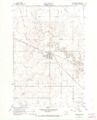
The town of McLaughlin serves as the central hub of this mid-1960s survey, situated along the vital corridor of the Chicago Milwaukee St Paul and Pacific railroad. The landscape is defined by the winding course of Oak Creek, which meanders eastward through the northern portion of the quadrangle. The town's infrastructure at this time includes a dedicated Landing Strip and a Sewage Disposal Pond on its western outskirts, while the Protestant Cem is located to the north, overlooking the creek valley.
Find a feature on this map
10 named features on this map. Tap any name to fly to it.
Don’t see what you’re looking for? This feature index may not catch every label — zoom into the map to look around manually.
Map Details
Editions of this 1966 McLaughlin Map
2 editions found
Other maps of this area

1953 · McIntosh
USGS Topo · 1:250,000

1956 · Wakpala NW
USGS Topo · 1:24,000

1956 · Little Eagle
USGS Topo · 1:24,000

1956 · Little Eagle NW
USGS Topo · 1:24,000

1958 · McIntosh
USGS Topo · 1:250,000

1966 · McLaughlin NE
USGS Topo · 1:24,000

1966 · Mahto
USGS Topo · 1:24,000

1966 · Mahto NW
USGS Topo · 1:24,000

1971 · McLaughlin SW
USGS Topo · 1:24,000
1971 · Maple Leaf
USGS Topo · 1:24,000