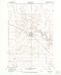
1966 Map of McLaughlin
USGS Topo · Published 1967About this map
The town of McLaughlin serves as a critical junction on the Chicago Milwaukee St Paul and Pacific railroad, which bisects the landscape of Corson County diagonally from northwest to southeast. This mid-1960s survey reveals a community anchored by transit and local industry, with multiple Gravel Pits and a dedicated Landing Strip adjacent to the town's core. The terrain is defined by the winding course of Oak Creek, which meanders through the northern sections, creating a sharp contrast between the riparian breaks and the surrounding upland plateaus. Cultural markers like the Protestant Cem and the division of Lincoln and McLaughlin townships provide clear reference points for genealogists and local historians tracking the development of the Standing Rock Reservation area during this period of the twentieth century.
Find a feature on this map
10 named features on this map. Tap any name to fly to it.
Don’t see what you’re looking for? This feature index may not catch every label — zoom into the map to look around manually.
Map Details
Editions of this 1966 McLaughlin Map
2 editions found
Other maps of this area

1953 · McIntosh
USGS Topo · 1:250,000

1956 · Wakpala NW
USGS Topo · 1:24,000

1956 · Little Eagle
USGS Topo · 1:24,000

1956 · Little Eagle NW
USGS Topo · 1:24,000

1958 · McIntosh
USGS Topo · 1:250,000

1966 · McLaughlin
USGS Topo · 1:24,000

1966 · McLaughlin NE
USGS Topo · 1:24,000

1966 · Mahto
USGS Topo · 1:24,000

1966 · Mahto NW
USGS Topo · 1:24,000

1971 · McLaughlin SW
USGS Topo · 1:24,000