
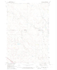
1971 Map of McLaughlin SW
USGS Topo · Published 1974About this map
The Chicago Milwaukee St Paul and Pacific railroad cuts a diagonal path across the northern expanse of this Corson County landscape, serving as the primary infrastructure for this prairie region. Grounded in the early 1970s, the terrain is defined by large township divisions including Cadillac, Lincoln, and McLaughlin. The map illustrates a predominantly rural and open geography, where elevation contours and sections mark the subtle rises of the South Dakota plains. Aside from the railway corridor, industrial activity is represented by a small Gravel Pit, pointing toward the local resource extraction necessary for road maintenance and development in this Missouri River Basin territory.
Find a feature on this map
5 named features on this map. Tap any name to fly to it.
Don’t see what you’re looking for? This feature index may not catch every label — zoom into the map to look around manually.
Map Details
Editions of this 1971 McLaughlin SW Map
This is the sole edition of this map. No revisions or reprints were ever made.
Other maps of this area

1953 · McIntosh
USGS Topo · 1:250,000

1956 · Little Eagle
USGS Topo · 1:24,000

1956 · Bullhead
USGS Topo · 1:24,000

1956 · Little Eagle NW
USGS Topo · 1:24,000

1956 · Miscol NE
USGS Topo · 1:24,000

1958 · McIntosh
USGS Topo · 1:250,000

1966 · McLaughlin
USGS Topo · 1:24,000

1966 · McLaughlin NE
USGS Topo · 1:24,000
1971 · Maple Leaf
USGS Topo · 1:24,000

1972 · Walker
USGS Topo · 1:24,000