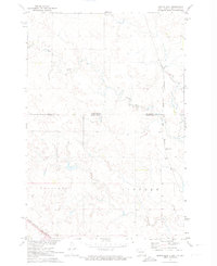
1971 Map of Maple Leaf
USGS Topo · Published 1974About this map
Maple Leaf sits along the Chicago Milwaukee St Paul and Pacific railroad, serving as a focal point in this 1971 survey of the northern Great Plains. The landscape is defined by the winding course of Oak Creek, which meanders eastward toward the rail line. This map documents a sparsely populated ranching and farming region on the Standing Rock Indian Reservation, where large land divisions like Lincoln and Cadillac characterize the township structure. The topography is meticulously detailed, showing the gentle rises and coulees typical of the area, as well as the political boundary where North Dakota and South Dakota meet. The presence of the Sioux County and Corson County line further illustrates the jurisdictional complexity of this borderland territory during the early 1970s.
Find a feature on this map
7 named features on this map. Tap any name to fly to it.
Don’t see what you’re looking for? This feature index may not catch every label — zoom into the map to look around manually.
Map Details
Editions of this 1971 Maple Leaf Map
This is the sole edition of this map. No revisions or reprints were ever made.
Other maps of this area

1953 · McIntosh
USGS Topo · 1:250,000

1954 · Bismarck
USGS Topo · 1:250,000

1956 · Bullhead
USGS Topo · 1:24,000

1958 · Bismarck
USGS Topo · 1:250,000

1958 · McIntosh
USGS Topo · 1:250,000

1966 · McLaughlin
USGS Topo · 1:24,000

1966 · McLaughlin NE
USGS Topo · 1:24,000
1971 · Selfridge SE
USGS Topo · 1:24,000

1971 · Selfridge
USGS Topo · 1:24,000

1971 · Pamplin Hills
USGS Topo · 1:24,000
Featured Places
- McLaughlin, SD
- Fort Yates District, ND
- Porcupine District, ND
- Rock Creek District, SD
- Maple Leaf, McLaughlin