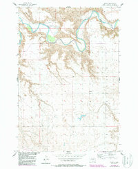
1956 Map of Miscol
USGS Topo · Published 1987About this map
The Grand River carves a deep, winding path through the northern portion of this landscape, its steep bluffs and narrow riverbanks defining the terrain of the Standing Rock Indian Reservation. At the time of this 1950s field check, the rural community of Miscol appears as a small gathering of structures on the high ground south of the river valley. The presence of Brown Ch near the northern boundary suggests the importance of local church congregations in anchoring this sparsely settled region of Corson County. The map details a network of section lines and secondary roads that connect isolated farmsteads and points of interest, illustrating the enduring agricultural and ranching character of the Dakotas during the mid-20th century.
Find a feature on this map
4 named features on this map. Tap any name to fly to it.
Don’t see what you’re looking for? This feature index may not catch every label — zoom into the map to look around manually.
Map Details
Editions of this 1956 Miscol Map
2 editions found
Other maps of this area

1953 · McIntosh
USGS Topo · 1:250,000

1956 · Miscol SW
USGS Topo · 1:24,000

1956 · Black Horse NE
USGS Topo · 1:24,000

1956 · Bullhead
USGS Topo · 1:24,000

1956 · Black Horse SE
USGS Topo · 1:24,000

1956 · Miscol SE
USGS Topo · 1:24,000

1956 · Miscol
USGS Topo · 1:24,000

1956 · Bullhead SW
USGS Topo · 1:24,000

1956 · Miscol NE
USGS Topo · 1:24,000

1958 · McIntosh
USGS Topo · 1:250,000