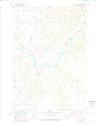
1956 Map of Black Horse NE
USGS Topo · Published 1978About this map
The Grand River meanders across this northern South Dakota landscape within the Standing Rock Indian Reservation, serving as the primary geographic corridor for this 1950s survey. The terrain is defined by a series of drainages, including White Shirt Creek and Hump Creek in the north, and Firesteel Creek to the south. Human presence is sparse, centered on small landmarks like Holy Spirit Church and an adjacent Cemetery near the southern boundary. The map provides a record of early land use in Liberty township, where small extraction efforts are noted by several Pits and a solitary Pit near the river. This document was produced as part of the Department of the Interior's Missouri River Basin development program, illustrating the remote agricultural and natural character of Corson County before late 20th-century shifts.
Find a feature on this map
10 named features on this map. Tap any name to fly to it.
Don’t see what you’re looking for? This feature index may not catch every label — zoom into the map to look around manually.
Map Details
Editions of this 1956 Black Horse NE Map
3 editions found
Other maps of this area

1953 · McIntosh
USGS Topo · 1:250,000

1956 · Miscol SW
USGS Topo · 1:24,000

1956 · Black Horse NE
USGS Topo · 1:24,000

1956 · Black Horse SW
USGS Topo · 1:24,000

1956 · Black Horse SE
USGS Topo · 1:24,000

1956 · Black Horse
USGS Topo · 1:24,000

1956 · Miscol
USGS Topo · 1:24,000

1956 · Bullhead SW
USGS Topo · 1:24,000

1958 · McIntosh
USGS Topo · 1:250,000

1972 · McIntosh SW
USGS Topo · 1:24,000