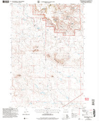
2005 Map of McKenzie Butte
USGS Topo · Published 2007About this map
South Cave Hills dominate this portion of the Custer National Forest, where high plateaus and buttes rise sharply above the drainages of Jones Creek and Boxelder Creek. The landscape reflects a dual economy of traditional ranching and modern energy extraction, as seen in the sprawling Oil Field and isolated Oil Well sites west of the Field Road. Ranching history is anchored by family-named operations like Butler Ranch, R Johnson Ranch, and the Cave Hills Cattle Co Ranch.
Find a feature on this map
39 named features on this map. Tap any name to fly to it.
Don’t see what you’re looking for? This feature index may not catch every label — zoom into the map to look around manually.
Map Details
Editions of this 2005 McKenzie Butte Map
This is the sole edition of this map. No revisions or reprints were ever made.
Other maps of this area

1935 · Reva
USGS Topo · 1:125,000

1935 · Buffalo
USGS Topo · 1:125,000

1954 · Lemmon
USGS Topo · 1:250,000

1957 · Lemmon
USGS Topo · 1:250,000

1968 · Ludlow
USGS Topo · 1:24,000

1969 · Ladner
USGS Topo · 1:24,000

1969 · Ladner SE
USGS Topo · 1:24,000

1971 · Buffalo
USGS Topo · 1:24,000
1971 · Lahti Butte
USGS Topo · 1:24,000

1971 · McKenzie Butte
USGS Topo · 1:24,000