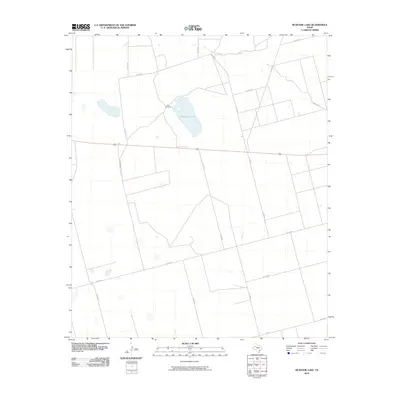
2010 Map of McKenzie Lake
USGS Topo · Published 2010About this map
McKenzie Lake sits at the center of this Gaines County landscape, which is defined by the organized grid of West Texas ranch roads and a sparse ranching infrastructure. The presence of Twin Windmills near the shoreline of the lake suggests a reliance on groundwater and traditional wind-power for livestock and land management in this arid region. The network of roads, including Co Rd 104 and Co Rd 418, provides a clear view of how large landholdings were partitioned and accessed in the early 21st century. This survey documents the intersection of natural depressions and human-built infrastructure in a corner of the South Plains where water remains the most critical resource.
Find a feature on this map
16 named features on this map. Tap any name to fly to it.
Don’t see what you’re looking for? This feature index may not catch every label — zoom into the map to look around manually.
Map Details
Editions of this 2010 McKenzie Lake Map
This is the sole edition of this map. No revisions or reprints were ever made.
Other maps of this area

1954 · Hobbs
USGS Topo · 1:250,000

1958 · Hobbs
USGS Topo · 1:250,000

1969 · Welch SW
USGS Topo · 1:24,000

1970 · Cedar Point Ranch
USGS Topo · 1:24,000

1970 · Patricia SW
USGS Topo · 1:24,000

1970 · McKenzie Lake NW
USGS Topo · 1:24,000

1970 · McKenzie Lake SE
USGS Topo · 1:24,000
1970 · Loop SW
USGS Topo · 1:24,000

1970 · Sand
USGS Topo · 1:24,000

1970 · McKenzie Lake
USGS Topo · 1:24,000