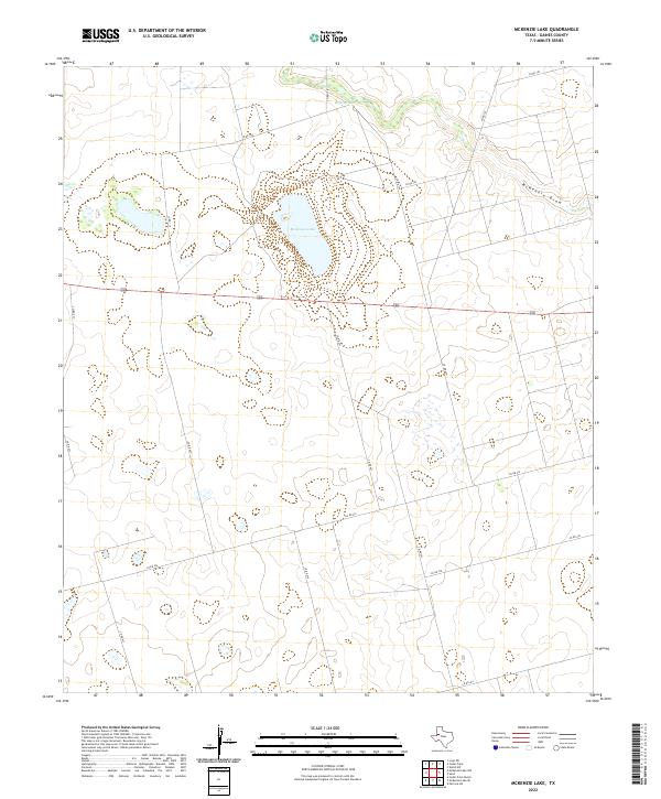
2022 Map of McKenzie Lake
USGS Topo · Published 2022About this map
McKenzie Lake and the ephemeral drainage of McKenzie Draw dominate this portion of the Texas Panhandle landscape in Gaines County. The map reveals a land defined by its hydrology, where Balch Springs feeds into seasonal wetlands and depressions across a semi-arid plain. This area exhibits a distinct grid-based rural development pattern, with a network of local routes such as Co Rd 104 and Co Rd 102 providing access to isolated homesteads or agricultural lands. The presence of 180 serves as the primary east-west corridor, cutting a straight line through the basin-like terrain. The surveyor's notes from the U.S. Geological Survey indicate a landscape shaped by intermittent water and wide-open spaces, characteristic of the High Plains region.
Find a feature on this map
20 named features on this map. Tap any name to fly to it.
Don’t see what you’re looking for? This feature index may not catch every label — zoom into the map to look around manually.
Map Details
Editions of this 2022 McKenzie Lake Map
This is the sole edition of this map. No revisions or reprints were ever made.
Other maps of this area

1954 · Hobbs
USGS Topo · 1:250,000

1958 · Hobbs
USGS Topo · 1:250,000

1969 · Welch SW
USGS Topo · 1:24,000

1970 · Cedar Point Ranch
USGS Topo · 1:24,000

1970 · Patricia SW
USGS Topo · 1:24,000

1970 · McKenzie Lake NW
USGS Topo · 1:24,000

1970 · McKenzie Lake SE
USGS Topo · 1:24,000
1970 · Loop SW
USGS Topo · 1:24,000

1970 · Sand
USGS Topo · 1:24,000

1970 · McKenzie Lake
USGS Topo · 1:24,000