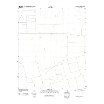
2010 Map of McKenzie Lake NW
USGS Topo · Published 2010About this map
Huat Oil Field occupies a central role in this West Texas landscape, illustrating the region's enduring ties to energy production. The terrain is organized by a geometric grid of county roads and ranch passages, including Ranch Rd 303 and Fairview Rd, which facilitate movement through this sparsely populated section of Gaines County. A solitary landmark, the CedarPoint Windmill, stands near the southern edge of the sheet, signaling the vital role of groundwater management for local ranching and agricultural operations. The road network, comprising labels like Co Rd 102 and Co Rd 421, reveals a high degree of land partitioning typical of the High Plains, where vast stretches are punctuated by the mechanical infrastructure of the petroleum industry.
Find a feature on this map
15 named features on this map. Tap any name to fly to it.
Don’t see what you’re looking for? This feature index may not catch every label — zoom into the map to look around manually.
Map Details
Editions of this 2010 McKenzie Lake NW Map
This is the sole edition of this map. No revisions or reprints were ever made.
Other maps of this area

1954 · Hobbs
USGS Topo · 1:250,000

1958 · Hobbs
USGS Topo · 1:250,000

1970 · Seminole NE
USGS Topo · 1:24,000

1970 · Cedar Point Ranch
USGS Topo · 1:24,000

1970 · Seagraves SE
USGS Topo · 1:24,000

1970 · McKenzie Lake NW
USGS Topo · 1:24,000

1970 · Seminole SE
USGS Topo · 1:24,000

1970 · McKenzie Lake SE
USGS Topo · 1:24,000
1970 · Loop SW
USGS Topo · 1:24,000

1970 · McKenzie Lake
USGS Topo · 1:24,000