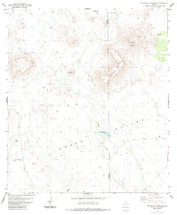
1983 Map of McKinney Mountain
USGS Topo · Published 1984About this map
Green Valley and Paradise Valley define the high-altitude topography of this Trans-Pecos landscape at the border of Presidio and Brewster counties. The terrain is marked by prominent igneous features, most notably the high summit of Mc Kinney Mountain and the distinctive Turney Peak to its north. In the lower reaches of the basins, water sources like Montgomery Lake, fed by Crystal Creek, provide rare points of relief in an otherwise arid environment. Evidence of late-twentieth-century activity is limited but clear, with a Landing Strip and a few isolated Jeep Trails providing the only reliable access through the rugged draws and canyons. For the geologist, the presence of The Dike and scattered Drill Hole locations suggests an era of continued mineral exploration in this remote portion of the Big Bend region.
Find a feature on this map
14 named features on this map. Tap any name to fly to it.
Don’t see what you’re looking for? This feature index may not catch every label — zoom into the map to look around manually.
Map Details
Editions of this 1983 McKinney Mountain Map
This is the sole edition of this map. No revisions or reprints were ever made.
Other maps of this area

1917 · Agua Fria
USGS Topo · 1:62,500

1917 · Tascotal Mesa
USGS Topo · 1:62,500

1917 · Buck Hill
USGS Topo · 1:62,500

1918 · Buck Hill
USGS Topo · 1:62,500

1918 · Jordan Gap
USGS Topo · 1:62,500

1925 · Buck Hill
USGS Topo · 1:62,500

1930 · Jordan Gap
USGS Topo · 1:62,500

1937 · Agua Fria
USGS Topo · 1:62,500

1944 · Tascotal Mesa
USGS Topo · 1:62,500

1959 · Emory Peak
USGS Topo · 1:250,000