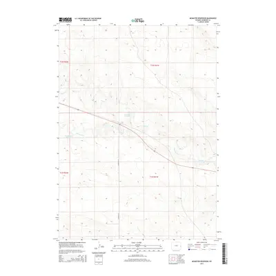
2015 Map of McMaster Reservoir
USGS Topo · Published 2015About this map
The Niobrara River carves a path through this section of eastern Wyoming, where water management defines the high plains landscape. This 2015 survey highlights the critical infrastructure required for ranching and agriculture in Niobrara County, featuring several named catchments including McMaster Reservoir, Christian Reservoir, and Dean Reservoir Number 1. These man-made features, fed by the seasonal flows of Duck Cr, illustrate the historical and ongoing efforts to capture runoff in an arid environment. The map shows a region organized by the Public Land Survey System, with the north-south transit of McMaster Rd and the east-west corridor of Route 20 serving as the primary arteries for local commerce and land access across the township and range boundaries of the T31N and T32N blocks.
Find a feature on this map
11 named features on this map. Tap any name to fly to it.
Don’t see what you’re looking for? This feature index may not catch every label — zoom into the map to look around manually.
Map Details
Editions of this 2015 McMaster Reservoir Map
This is the sole edition of this map. No revisions or reprints were ever made.
Other maps of this area

1954 · Torrington
USGS Topo · 1:250,000

1958 · Torrington
USGS Topo · 1:250,000

1974 · Mc Master Reservoir
USGS Topo · 1:24,000

1977 · Hileman Draw
USGS Topo · 1:24,000

1977 · Van Tassell
USGS Topo · 1:24,000

1977 · Van Tassell SE
USGS Topo · 1:24,000

1977 · Prairie Center
USGS Topo · 1:24,000
1978 · Node
USGS Topo · 1:24,000

1978 · Kirtley SW
USGS Topo · 1:24,000

1978 · Kirtley
USGS Topo · 1:24,000