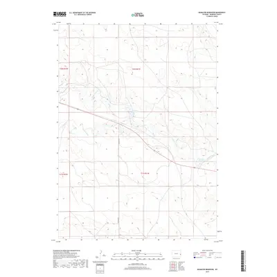
2017 Map of McMaster Reservoir
USGS Topo · Published 2017About this map
The Niobrara River winds through this high plains landscape of Niobrara County, anchoring a terrain defined by subtle drainage patterns and seasonal water storage. Recent decades have seen the development of essential water management features, including the namesake McMaster Reservoir in the southeast and Christian Reservoir further north. These water bodies reflect the ongoing importance of livestock and resource management in this corner of Wyoming. The survey area is bisected by McMaster Rd, a primary transit artery connecting these remote sections. Tributaries like Duck Creek and Duck Cr channel the scarce precipitation toward the Niobrara, illustrating the natural watercourse system that has shaped land use across these townships since the early days of ranching.
Find a feature on this map
10 named features on this map. Tap any name to fly to it.
Don’t see what you’re looking for? This feature index may not catch every label — zoom into the map to look around manually.
Map Details
Editions of this 2017 McMaster Reservoir Map
This is the sole edition of this map. No revisions or reprints were ever made.
Other maps of this area

1954 · Torrington
USGS Topo · 1:250,000

1958 · Torrington
USGS Topo · 1:250,000

1974 · Mc Master Reservoir
USGS Topo · 1:24,000

1977 · Hileman Draw
USGS Topo · 1:24,000

1977 · Van Tassell
USGS Topo · 1:24,000

1977 · Van Tassell SE
USGS Topo · 1:24,000

1977 · Prairie Center
USGS Topo · 1:24,000
1978 · Node
USGS Topo · 1:24,000

1978 · Kirtley SW
USGS Topo · 1:24,000

1978 · Kirtley
USGS Topo · 1:24,000