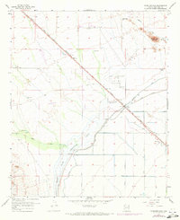
1957 Map of McMicken Dam
USGS Topo · Published 1972About this map
The Atchison Topeka and Santa Fe railroad cuts a sharp diagonal across this desert landscape, anchoring the small settlement of Beardsley. This 1957 survey, with revisions from 1971, highlights the critical water management systems essential to Maricopa County, including the Mc Micken Dam Spillway 1354 and the massive Detention Basin designed to capture runoff from the Trilby Wash. The area also served a significant military and civil aviation role, evidenced by Luke Auxiliary Field No 1 and two additional auxiliary fields managed by the City of Phoenix. Beyond the engineered water channels and canals like the Beardsley Canal, the terrain rises toward Bunker Peak, where the drainage of Paddelford Wash and Lake Bonita define the arid topography north of Bard Ranch.
Find a feature on this map
30 named features on this map. Tap any name to fly to it.
Don’t see what you’re looking for? This feature index may not catch every label — zoom into the map to look around manually.
Map Details
Editions of this 1957 McMicken Dam Map
4 editions found
Other maps of this area

1954 · Phoenix
USGS Topo · 1:250,000

1957 · Phoenix
USGS Topo · 1:250,000

1957 · White Tank Mts. SE
USGS Topo · 1:24,000

1957 · White Tank Mts. NE
USGS Topo · 1:24,000

1957 · Calderwood Butte
USGS Topo · 1:24,000

1957 · McMicken Dam
USGS Topo · 1:24,000

1957 · El Mirage
USGS Topo · 1:24,000

1957 · Waddell
USGS Topo · 1:24,000

1957 · White Tank Mts.
USGS Topo · 1:62,500

1958 · Phoenix
USGS Topo · 1:250,000