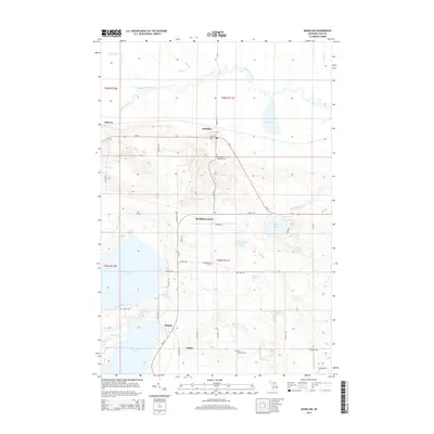
2014 Map of McMillan
USGS Topo · Published 2014About this map
The Tahquamenon River snakes across the northern portion of this Luce County terrain, providing a stark hydrological contrast to the expansive Manistique Lake and N-Manistique Lake that dominate the southwestern corner. This area of the Upper Peninsula is characterized by complex drainage patterns, with smaller water bodies like McCormick Lake and Lost Lake situated among a network of rural roads. Settlement is concentrated along the east-west corridor of M-28, where the community of McMillan sits near the Columbus Township Cem. Further south, the map reveals smaller hamlets and historical points of interest such as McMillan Corner, Helmer, and Marks. Genealogists will find particular value in the placement of the E Lakefield Cem and Old E Lakefield Cem, which anchor the local history of these lakeside and riverside townships.
Find a feature on this map
54 named features on this map. Tap any name to fly to it.
Don’t see what you’re looking for? This feature index may not catch every label — zoom into the map to look around manually.
Map Details
Editions of this 2014 McMillan Map
This is the sole edition of this map. No revisions or reprints were ever made.
Other maps of this area

1931 · Gould City NE
USGS Topo · 1:31,680

1931 · Gould City NW
USGS Topo · 1:31,680

1931 · Seney SE
USGS Topo · 1:31,680

1931 · Blaney NE
USGS Topo · 1:31,680

1954 · Sault Sainte Marie
USGS Topo · 1:250,000

1956 · Sault Sainte Marie
USGS Topo · 1:250,000

1957 · Sault Sainte Marie
USGS Topo · 1:250,000

1958 · Sault Sainte Marie
USGS Topo · 1:250,000

1962 · Auger Lake
USGS Topo · 1:24,000
1972 · Hardwood Island
USGS Topo · 1:24,000