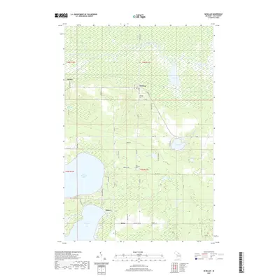
2019 Map of McMillan
USGS Topo · Published 2019About this map
The Tahquamenon River flows across the northern reaches of this Luce County landscape, meandering through a series of wetlands and sloughs such as Kaketon Slough. To the south, the terrain transitions into a more settled region defined by the large waters of North Manistique Lake and Manistique Lake. This 2019 survey documents the rural character of the area around McMillan and Helmer, where the road network follows established township lines. Genealogists and local historians will find several burial sites including Columbus Township Cem near the town center, and both the East Lakefield Cem and Old East Lakefield Cem further south. The map illustrates the hydrological connection between various water bodies like McCormick Lake, Locke Lake, and East Lake, providing a clear record of the modern shoreline and drainage patterns in this part of Michigan's Upper Peninsula.
Find a feature on this map
65 named features on this map. Tap any name to fly to it.
Don’t see what you’re looking for? This feature index may not catch every label — zoom into the map to look around manually.
Map Details
Editions of this 2019 McMillan Map
This is the sole edition of this map. No revisions or reprints were ever made.
Other maps of this area

1931 · Gould City NE
USGS Topo · 1:31,680

1931 · Gould City NW
USGS Topo · 1:31,680

1931 · Seney SE
USGS Topo · 1:31,680

1931 · Blaney NE
USGS Topo · 1:31,680

1954 · Sault Sainte Marie
USGS Topo · 1:250,000

1956 · Sault Sainte Marie
USGS Topo · 1:250,000

1957 · Sault Sainte Marie
USGS Topo · 1:250,000

1958 · Sault Sainte Marie
USGS Topo · 1:250,000

1962 · Auger Lake
USGS Topo · 1:24,000
1972 · Hardwood Island
USGS Topo · 1:24,000