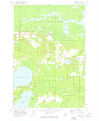
1973 Map of McMillan
USGS Topo · Published 1977About this map
The Soo Line corridor and the Tahquamenon River State Forest define this 1973 landscape in the Upper Peninsula. Centered on the settlement of McMillan, the map captures a transition from the marshy lowlands of Laketon Slough and the winding Tahquamenon River to the open waters of North Manistique Lake. This area reflects a mid-century balance between working timberlands, small-scale farming indicated by the fine fence lines, and the growing recreation industry at Helmer and Laketon.
Find a feature on this map
40 named features on this map. Tap any name to fly to it.
Don’t see what you’re looking for? This feature index may not catch every label — zoom into the map to look around manually.
Map Details
Editions of this 1973 McMillan Map
This is the sole edition of this map. No revisions or reprints were ever made.
Other maps of this area

1931 · Gould City NE
USGS Topo · 1:31,680

1931 · Gould City NW
USGS Topo · 1:31,680

1931 · Seney SE
USGS Topo · 1:31,680

1931 · Blaney NE
USGS Topo · 1:31,680

1954 · Sault Sainte Marie
USGS Topo · 1:250,000

1956 · Sault Sainte Marie
USGS Topo · 1:250,000

1957 · Sault Sainte Marie
USGS Topo · 1:250,000

1958 · Sault Sainte Marie
USGS Topo · 1:250,000

1962 · Auger Lake
USGS Topo · 1:24,000
1972 · Hardwood Island
USGS Topo · 1:24,000