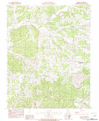
1982 Map of McNatt
USGS Topo · Published 1982About this map
McNatt and the surrounding rural landscape of McDonald County are defined by a complex network of hollows and ridges during the early 1980s. The settlement of Plainview sits near the center of the sheet, while the southern reach is dominated by the winding path of Big Sugar Creek and the intersection of Big Cedar Hollow and Little Cedar Hol. Evidence of the area's natural resource history is visible in features like Coal Mine Hol and the Elkhorn Tower State Public Hunting Grounds, reflecting a balance between extraction and conservation.
Find a feature on this map
25 named features on this map. Tap any name to fly to it.
Don’t see what you’re looking for? This feature index may not catch every label — zoom into the map to look around manually.
Map Details
Editions of this 1982 McNatt Map
This is the sole edition of this map. No revisions or reprints were ever made.
Other maps of this area

1916 · Neosho
USGS Topo · 1:62,500

1940 · Noel
USGS Topo · 1:62,500

1941 · Rocky Comfort
USGS Topo · 1:62,500

1943 · Ritchey
USGS Topo · 1:62,500

1943 · Noel
USGS Topo · 1:62,500

1943 · Rocky Comfort
USGS Topo · 1:62,500

1954 · Tulsa
USGS Topo · 1:250,000

1958 · Tulsa
USGS Topo · 1:250,000

1963 · Tulsa
USGS Topo · 1:250,000
1972 · Neosho West
USGS Topo · 1:24,000