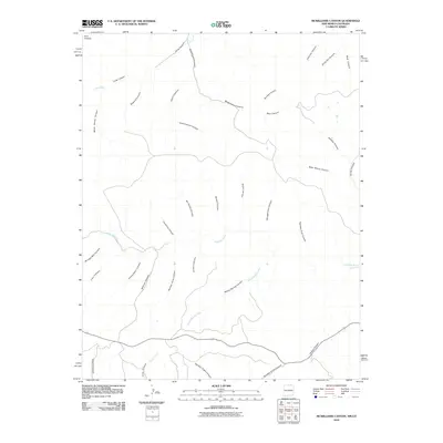
2010 Map of McWilliams Canyon
USGS Topo · Published 2010About this map
The Park Plateau landscape of northern New Mexico and southern Colorado is defined here by a massive network of drainage systems cutting through high terrain. The Canadian River meanders across the central portion of the map, fed by a complex series of intermittent streams and named canyons that suggest a long history of water erosion and local land-use. Many of these features, such as Taber Morey Canyon, Dargot Canyon, and Bruggerman Canyon, bear the names of early settlers or ranching families, providing valuable clues for those tracing regional genealogy. The northern reaches are dominated by McWilliams Canyon and Long Canyon, while the southern area shows the convergence of Crow Creek and Number Eight Canyon. This map captures the intricate topography of the border region before modern development could obscure these traditional drainage patterns and family-named landmarks like Shingle Mill Canyon.
Find a feature on this map
35 named features on this map. Tap any name to fly to it.
Don’t see what you’re looking for? This feature index may not catch every label — zoom into the map to look around manually.
Map Details
Editions of this 2010 McWilliams Canyon Map
This is the sole edition of this map. No revisions or reprints were ever made.
Other maps of this area

1891 · Spanish Peaks
USGS Topo · 1:125,000

1893 · Spanish Peaks
USGS Topo · 1:125,000

1895 · Spanish Peaks
USGS Topo · 1:125,000

1897 · Spanish Peaks
USGS Topo · 1:125,000

1900 · Spanish Peaks
USGS Topo · 1:125,000

1915 · Brilliant
USGS Topo · 1:62,500

1951 · Valdez
USGS Topo · 1:24,000
1951 · Starkville
USGS Topo · 1:24,000

1954 · Raton
USGS Topo · 1:250,000

1954 · Trinidad
USGS Topo · 1:250,000