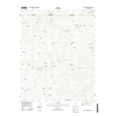
2013 Map of McWilliams Canyon
USGS Topo · Published 2013About this map
The Canadian River cuts through this high-desert borderland where Las Animas County meets New Mexico. This rugged topography is defined by a dense network of drainages and family-named landmarks, reflecting the historic ranching and timber heritage of the region. Distinctive features like Sawmill Canyon and Shingle Mill Canyon point toward the area's early industrial utility, while labels such as Joe Baker Canyon and Taber Morey Canyon preserve the names of individuals tied to this landscape. The confluence of Sheep Spring Creek and the river provides a rare corridor of water in an otherwise arid expanse of mesas and canyons. Modern road networks are minimal, leaving the natural contours of McWilliams Canyon and Six Horse Canyon to dictate the movement through the terrain. The map serves as a detailed record of the border's physical geography, from the heights of Rock Canyon to the deep recesses of Corduroy Canyon.
Find a feature on this map
41 named features on this map. Tap any name to fly to it.
Don’t see what you’re looking for? This feature index may not catch every label — zoom into the map to look around manually.
Map Details
Editions of this 2013 McWilliams Canyon Map
This is the sole edition of this map. No revisions or reprints were ever made.
Other maps of this area

1891 · Spanish Peaks
USGS Topo · 1:125,000

1893 · Spanish Peaks
USGS Topo · 1:125,000

1895 · Spanish Peaks
USGS Topo · 1:125,000

1897 · Spanish Peaks
USGS Topo · 1:125,000

1900 · Spanish Peaks
USGS Topo · 1:125,000

1915 · Brilliant
USGS Topo · 1:62,500

1951 · Valdez
USGS Topo · 1:24,000
1951 · Starkville
USGS Topo · 1:24,000

1954 · Raton
USGS Topo · 1:250,000

1954 · Trinidad
USGS Topo · 1:250,000