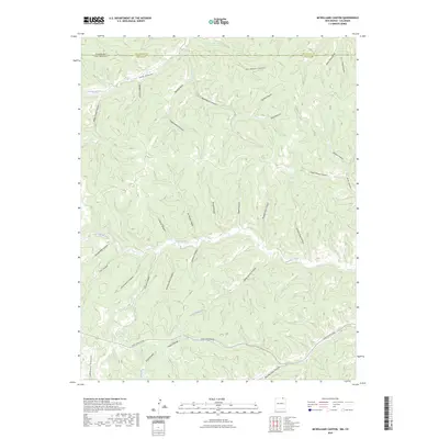
2023 Map of McWilliams Canyon
USGS Topo · Published 2023About this map
The Canadian River cuts through this high-altitude landscape where the Colorado-New Mexico state line meets the Las Animas and Colfax county borders. The terrain is defined by an intricate network of drainages named for early settlers and industrial uses, such as Joe Baker Canyon, Taber Morey Canyon, and Shingle Mill Canyon. These names suggest a history of localized timber work and ranching in a region where water sources like Sheep Spring Creek and Long Creek were vital for survival. Modern access is primarily represented by York Canyon Rd, which skirts the southern canyons. The many numbered features, including Number Five Canyon and Number Eight Canyon, reflect a systematic approach to land management and resource extraction in this corner of the Sangre de Cristo foothills.
Find a feature on this map
37 named features on this map. Tap any name to fly to it.
Don’t see what you’re looking for? This feature index may not catch every label — zoom into the map to look around manually.
Map Details
Editions of this 2023 McWilliams Canyon Map
This is the sole edition of this map. No revisions or reprints were ever made.
Other maps of this area

1891 · Spanish Peaks
USGS Topo · 1:125,000

1893 · Spanish Peaks
USGS Topo · 1:125,000

1895 · Spanish Peaks
USGS Topo · 1:125,000

1897 · Spanish Peaks
USGS Topo · 1:125,000

1900 · Spanish Peaks
USGS Topo · 1:125,000

1915 · Brilliant
USGS Topo · 1:62,500

1951 · Valdez
USGS Topo · 1:24,000
1951 · Starkville
USGS Topo · 1:24,000

1954 · Raton
USGS Topo · 1:250,000

1954 · Trinidad
USGS Topo · 1:250,000