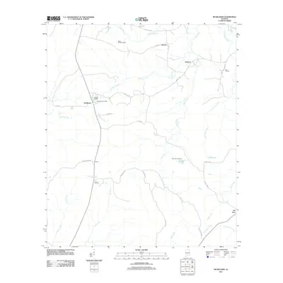
2011 Map of McWilliams
USGS Topo · Published 2011About this map
The McWilliams Post Office anchors the small community of McWilliams in this rural Wilcox County landscape. The area is defined by a dense network of watercourses, including the south-flowing Bear Creek and Little Turkey Creek, which feed into the West Sepulga River in the southeastern corner. This drainage pattern shaped the early settlement of the region, where family-named landmarks like the Mack McClurkin Dam and McGowin Pond Dam point to local efforts to manage the water for ponds and agricultural use.
Find a feature on this map
37 named features on this map. Tap any name to fly to it.
Don’t see what you’re looking for? This feature index may not catch every label — zoom into the map to look around manually.
Map Details
Editions of this 2011 McWilliams Map
This is the sole edition of this map. No revisions or reprints were ever made.
Other maps of this area

1953 · Andalusia
USGS Topo · 1:250,000

1957 · Andalusia
USGS Topo · 1:250,000

1967 · Beatrice
USGS Topo · 1:24,000

1971 · Skinnerton
USGS Topo · 1:24,000

1971 · Bethel
USGS Topo · 1:24,000

1971 · Beatrice
USGS Topo · 1:24,000
1981 · Rosebud
USGS Topo · 1:24,000
1981 · Oak Hill
USGS Topo · 1:24,000

1981 · Pine Apple North
USGS Topo · 1:24,000
1981 · Nadawah
USGS Topo · 1:24,000