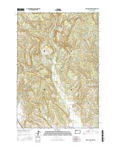
2017 Map of Meacham Corner
USGS Topo · Published 2017About this map
Meacham Corner and the small valley community of Mountaindale define the settlement pattern of this Washington County landscape, where the foothills meet the drainages of the East Fork Dairy Creek. The area is characterized by a high concentration of water management features, including Dam Site Reservoir, Spaniol Reservoir, and Sunago Reservoir, reflecting the region's agricultural and hydrologic needs. To the southeast, Pumpkin Ridge rises above the drainage of Gumm Creek, while the western edge of the map is dominated by the heights of Bald Mountain and Red Slide Hill. Family and local histories are preserved through landmarks like Raffety Cemetery and Arcade Cemetery, while the Banks-Vernonia State Trail traces a corridor of former rail activity. The presence of Gilbert Airport and various timber-access routes like NW Shermans Mill Rd indicate the modern intersection of private aviation and the timber economy in this portion of the Coast Range foothills.
Find a feature on this map
86 named features on this map. Tap any name to fly to it.
Don’t see what you’re looking for? This feature index may not catch every label — zoom into the map to look around manually.
Map Details
Editions of this 2017 Meacham Corner Map
This is the sole edition of this map. No revisions or reprints were ever made.
Other maps of this area

1915 · Hillsboro
USGS Topo · 1:62,500

1918 · Hillsboro
USGS Topo · 1:62,500

1922 · St. Helens
USGS Topo · 1:62,500

1940 · Hillsboro
USGS Topo · 1:62,500

1940 · Vernonia
USGS Topo · 1:62,500

1941 · St Helens
USGS Topo · 1:62,500

1941 · Gales Creek
USGS Topo · 1:62,500

1943 · Vernonia
USGS Topo · 1:62,500

1943 · St Helens
USGS Topo · 1:62,500

1948 · Vancouver
USGS Topo · 1:250,000