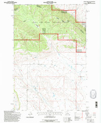
1995 Map of Mead Creek
USGS Topo · Published 1997About this map
Lewis and Clark National Forest dominates the northern half of this mid-1990s survey, where the Judith Musselshell Ranger District manages the high ground of the Little Belt Mountains transition. The landscape is defined by its drainage patterns, with Mead Creek and Roberts Creek flowing southward out of the forest toward more level terrain. Notable landmarks like the Radio Tower and Corral indicate the intersection of modern utility and traditional land use in this part of Montana. The county line between Judith Basin and Wheatland counties bisects the forest, tracing a path through Sawmill Canyon. To the south, the network of seasonal Spring labels and several irrigation Ditch lines illustrate the vital importance of water management in this high-plains environment near the headwaters of Antelope Creek and Hopley Creek.
Find a feature on this map
14 named features on this map. Tap any name to fly to it.
Don’t see what you’re looking for? This feature index may not catch every label — zoom into the map to look around manually.
Map Details
Editions of this 1995 Mead Creek Map
This is the sole edition of this map. No revisions or reprints were ever made.
Other maps of this area

1886 · Little Belt Mts.
USGS Topo · 1:250,000

1889 · Big Snowy Mountain
USGS Topo · 1:250,000

1893 · Big Snowy Mountain
USGS Topo · 1:250,000

1894 · Little Belt Mts.
USGS Topo · 1:250,000

1897 · Little Belt Mts.
USGS Topo · 1:250,000

1898 · Little Belt Mts.
USGS Topo · 1:250,000

1902 · Little Belt Mts.
USGS Topo · 1:250,000

1948 · White Sulphur Springs
USGS Topo · 1:250,000

1954 · Roundup
USGS Topo · 1:250,000

1958 · Roundup
USGS Topo · 1:250,000