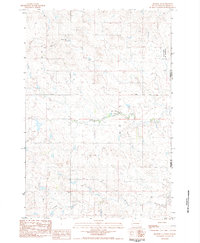
1983 Map of Meadow SE
USGS Topo · Published 1984About this map
Grand River Nat Grassland covers the northeastern portion of this Perkins County landscape, representing a significant area of public land management during the early 1980s. The terrain is defined by the winding paths of Black Horse Butte Creek and Darling Creek, which drain the open prairie. Transportation in this era was anchored by the Athboy Road, cutting a straight line across the center of the sheet and connecting isolated ranching interests. The map documents the rural boundary line between Perkins Co and Corson Co, providing a clear record of land division and topographical detail at a 5-meter contour interval. This survey illustrates the sparse, ranch-oriented settlement patterns characteristic of the High Plains before modern developments further altered the landscape.
Find a feature on this map
7 named features on this map. Tap any name to fly to it.
Don’t see what you’re looking for? This feature index may not catch every label — zoom into the map to look around manually.
Map Details
Editions of this 1983 Meadow SE Map
This is the sole edition of this map. No revisions or reprints were ever made.
Other maps of this area

1953 · McIntosh
USGS Topo · 1:250,000

1954 · Lemmon
USGS Topo · 1:250,000

1957 · Lemmon
USGS Topo · 1:250,000

1958 · McIntosh
USGS Topo · 1:250,000

1972 · Black Horse Butte NW
USGS Topo · 1:24,000

1972 · Black Horse Butte
USGS Topo · 1:24,000

1980 · McIntosh
USGS Topo · 1:100,000

1982 · Glad Valley NW
USGS Topo · 1:24,000

1983 · Coal Springs
USGS Topo · 1:24,000

1983 · Meadow NW
USGS Topo · 1:24,000