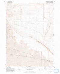
1991 Map of Meadow Spring
USGS Topo · Published 1991About this map
Newfoundland Evaporation Basin dominates the southern landscape of this Box Elder County survey, illustrating the industrial and topographical complexity of Utah's West Desert. The map captures a moment when desert infrastructure supported both heavy transit and extractive activity, evidenced by the prominent Lucin Cutoff and several Borrow Pits near the mountain foothills. The terrain transitions from the high elevations of the Hogup Mountains and Broom Mountain down into expansive flats marked simply as Mud. Human presence in this arid environment is localized around transportation and water management, featuring a remote Landing Strip, a designated Private road, and the isolated Meadow Spring. Notably, the map includes the Rio Buenaventura, a label referencing the historically mythical river that was once thought to connect the Great Basin to the Pacific Ocean, here associated with modern water works near the Canal.
Find a feature on this map
12 named features on this map. Tap any name to fly to it.
Don’t see what you’re looking for? This feature index may not catch every label — zoom into the map to look around manually.
Map Details
Editions of this 1991 Meadow Spring Map
This is the sole edition of this map. No revisions or reprints were ever made.
Other maps of this area

1954 · Brigham City
USGS Topo · 1:250,000

1958 · Brigham City
USGS Topo · 1:250,000

1962 · Brigham City
USGS Topo · 1:250,000

1969 · Dolphin Island West
USGS Topo · 1:24,000

1969 · Hogup Ridge South
USGS Topo · 1:24,000

1969 · Hogup Ridge North
USGS Topo · 1:24,000

1983 · Desert Peak
USGS Topo · 1:24,000

1983 · Round Mountain NW
USGS Topo · 1:24,000

1983 · Sheep Mountain
USGS Topo · 1:24,000

1983 · Groome
USGS Topo · 1:24,000