
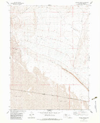
1983 Map of Sheep Mountain
USGS Topo · Published 1983About this map
Sheep Mountain dominates the northern horizon of this landscape in Box Elder County, where the high ground gives way to the expansive reaches of the Mud Flat. This 1983 edition, based on earlier photogrammetric methods and field checks, highlights a transition from desert peaks to the vast, level surfaces of the Great Salt Lake Desert region. Human activity is sparse on this terrain, primarily marked by a lone Jeep Trail that skirts the eastern edge of the quadrangle. The map is a study in topographic extremes, capturing the precise contouring of the mountain's slopes against the seemingly featureless white space of the surrounding flats, documenting a corner of the Great Basin as it remained in the early 1980s.
Find a feature on this map
3 named features on this map. Tap any name to fly to it.
Don’t see what you’re looking for? This feature index may not catch every label — zoom into the map to look around manually.
Map Details
Editions of this 1983 Sheep Mountain Map
This is the sole edition of this map. No revisions or reprints were ever made.
Other maps of this area

1954 · Brigham City
USGS Topo · 1:250,000

1958 · Brigham City
USGS Topo · 1:250,000

1962 · Brigham City
USGS Topo · 1:250,000

1969 · Hogup Bar
USGS Topo · 1:24,000

1971 · Red Dome
USGS Topo · 1:24,000

1971 · Matlin
USGS Topo · 1:24,000

1983 · Lemay
USGS Topo · 1:24,000

1983 · Terrace Mountain East
USGS Topo · 1:24,000

1983 · Groome
USGS Topo · 1:24,000
1983 · Meadow Spring
USGS Topo · 1:24,000