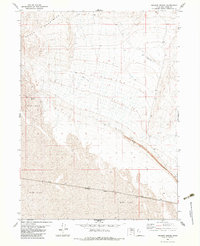
1983 Map of Meadow Spring
USGS Topo · Published 1983About this map
Hogup Mountains dominate the northern landscape of this Box Elder County quadrangle, where the steep terrain gives way to the expansive reaches of the Mud Flat. This 1983 survey captures the stark isolation of the Great Salt Lake Desert, characterized by minimal infrastructure and vast alkaline basins. A crucial corridor for transcontinental transit is marked by the Southern Pacific railroad line, which cuts across the southern portion of the sheet. Industrial activity and utility are evidenced by several Borrow Pits and a solitary Landing Strip, likely supporting maintenance or remote operations in this arid environment. The presence of Meadow Spring at the mountain base provides a rare focal point of natural water, while various Jeep Trails and private roads trace the sparse network of movement through the desert floor.
Find a feature on this map
8 named features on this map. Tap any name to fly to it.
Don’t see what you’re looking for? This feature index may not catch every label — zoom into the map to look around manually.
Map Details
Editions of this 1983 Meadow Spring Map
This is the sole edition of this map. No revisions or reprints were ever made.
Other maps of this area

1954 · Brigham City
USGS Topo · 1:250,000

1958 · Brigham City
USGS Topo · 1:250,000

1962 · Brigham City
USGS Topo · 1:250,000

1969 · Dolphin Island West
USGS Topo · 1:24,000

1969 · Hogup Ridge South
USGS Topo · 1:24,000

1969 · Hogup Ridge North
USGS Topo · 1:24,000

1983 · Desert Peak
USGS Topo · 1:24,000

1983 · Round Mountain NW
USGS Topo · 1:24,000

1983 · Sheep Mountain
USGS Topo · 1:24,000

1983 · Groome
USGS Topo · 1:24,000