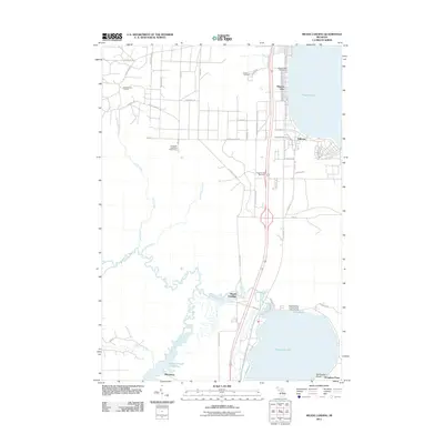
2011 Map of Meads Landing
USGS Topo · Published 2011About this map
Higgins Lake and Houghton Lake anchor this 2011 survey, connected by the meandering Muskegon River and the extensive Dead Stream Flooding. This area of Roscommon and Missaukee Counties is defined by its transition between recreation and resource extraction, notably featuring the East Norwich Oil Field in the northwest. Local history and genealogy are centered around the Higgins Lake Post Office and the small settlements of Meads Landing, Hillcrest, and Michelson. Preservation and wildlife management are evident through the Houghton Lake State Game Farm and the Houghton Lake State Forest Campground. The map also documents quiet resting places like Oakwood Cemetery and Heidemann Cemetery, while the modern transportation corridor of US-127 bypasses the older Old US Hwy 27.
Find a feature on this map
57 named features on this map. Tap any name to fly to it.
Don’t see what you’re looking for? This feature index may not catch every label — zoom into the map to look around manually.
Map Details
Editions of this 2011 Meads Landing Map
This is the sole edition of this map. No revisions or reprints were ever made.
Other maps of this area

1949 · Fletcher
USGS Topo · 1:62,500

1949 · Grayling
USGS Topo · 1:62,500

1950 · Cote Dame Marie
USGS Topo · 1:24,000

1950 · Fletcher
USGS Topo · 1:24,000

1951 · Pere Cheney
USGS Topo · 1:24,000

1954 · Traverse City
USGS Topo · 1:250,000

1956 · Houghton Lake
USGS Topo · 1:62,500

1958 · Traverse City
USGS Topo · 1:250,000

1963 · Prudenville
USGS Topo · 1:24,000
1963 · Lyon Manor
USGS Topo · 1:24,000