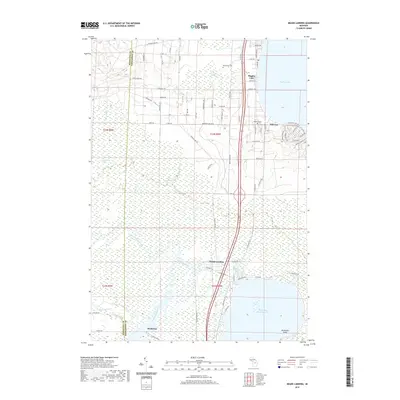
2019 Map of Meads Landing
USGS Topo · Published 2019About this map
Dead Stream Swamp dominates the central landscape of this northern Michigan quadrangle, where the Muskegon River meanders through expansive wetlands before reaching the southern settlement of Michelson. The geography is defined by its transition between these interior lowlands and the developed lakefronts. To the north, the shoreline of Higgins Lake supports the communities of Hillcrest and Higgins Lake, while the southern edge of the map opens into the North Bay Houghton Lake near McDonald Point. Cultural history is anchored by the presence of Oakwood Cem and Heidemann Cem, alongside the low-lying Heidemann Marsh. The layout of local routes, including the Snowmobile Trl and Old US Hwy 27, reflects a region shaped by both recreational access and its traditional river-and-swamp drainage patterns.
Find a feature on this map
72 named features on this map. Tap any name to fly to it.
Don’t see what you’re looking for? This feature index may not catch every label — zoom into the map to look around manually.
Map Details
Editions of this 2019 Meads Landing Map
This is the sole edition of this map. No revisions or reprints were ever made.
Other maps of this area

1949 · Fletcher
USGS Topo · 1:62,500

1949 · Grayling
USGS Topo · 1:62,500

1950 · Cote Dame Marie
USGS Topo · 1:24,000

1950 · Fletcher
USGS Topo · 1:24,000

1951 · Pere Cheney
USGS Topo · 1:24,000

1954 · Traverse City
USGS Topo · 1:250,000

1956 · Houghton Lake
USGS Topo · 1:62,500

1958 · Traverse City
USGS Topo · 1:250,000

1963 · Prudenville
USGS Topo · 1:24,000
1963 · Lyon Manor
USGS Topo · 1:24,000