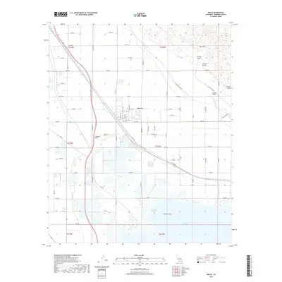
2018 Map of Mecca
USGS Topo · Published 2018About this map
Mecca sits at the nexus of California's low desert agricultural and geological landscape, positioned where the Coachella Valley meets the northern reaches of the Salton Sea. This 2018 survey illustrates the complex water management systems essential to the region, featuring the Coachella Canal and the Whitewater River as they channel through the Imperial Valley transition. The grid of the settlement is well-defined by local thoroughfares like Lincoln St and 66th Ave, serving as a hub for the surrounding groves and fields. To the northeast, the terrain rises sharply into the Mecca Hills, where natural landmarks such as Painted Canyon, Skeleton Canyon, and Surprise Valley contrast with the irrigated valley floor. The map also captures the seasonal drainage of Box Canyon Wash as it approaches Whitewater Cove, providing a clear record of the intersection between modern desert infrastructure and the desert's inherent topography.
Find a feature on this map
61 named features on this map. Tap any name to fly to it.
Don’t see what you’re looking for? This feature index may not catch every label — zoom into the map to look around manually.
Map Details
Editions of this 2018 Mecca Map
This is the sole edition of this map. No revisions or reprints were ever made.
Other maps of this area

1904 · Indio
USGS Topo · 1:125,000

1931 · Vallecito
USGS Topo · 1:125,000

1940 · Cottonwood Spring
USGS Topo · 1:62,500

1940 · Durmid
USGS Topo · 1:62,500

1941 · Coachella
USGS Topo · 1:62,500

1942 · Agua Dulce
USGS Topo · 1:62,500

1943 · Vallecito
USGS Topo · 1:125,000

1943 · Coachella
USGS Topo · 1:62,500

1944 · Agua Dulce
USGS Topo · 1:62,500

1944 · Cottonwood Spring
USGS Topo · 1:62,500