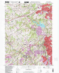
1995 Map of Media
USGS Topo · Published 1999About this map
The rolling landscape of Delaware and Chester Counties is defined here by the suburban expansion of Media and Newtown Square in the mid-1990s. This survey illustrates a complex social landscape where institutional history is deeply rooted, evidenced by the Fair Acres County Home, Sleighton Farm School, and several religious academies including the Villa Maria Academy for Girls. The transition from rural to suburban is marked by large protected spaces such as the Tyler Arboretum and Ridley Creek State Park, which preserve the wooded corridors along Ridley Creek. Along the southeastern edge, the concentration of civic life is centered around the Media Court House and Riddle Memorial Hospital, while the rail corridor of Septa connects established residential clusters like Glen Riddle, Lenni, and Wawa. The presence of Sycamore Mills and various older school sites like the Old Forge Sch provides a tangible link to the earlier agrarian and industrial character of the region.
Find a feature on this map
103 named features on this map. Tap any name to fly to it.
Don’t see what you’re looking for? This feature index may not catch every label — zoom into the map to look around manually.
Map Details
Editions of this 1995 Media Map
This is the sole edition of this map. No revisions or reprints were ever made.
Other maps of this area

1894 · Chester
USGS Topo · 1:62,500

1894 · Norristown
USGS Topo · 1:62,500

1895 · Norristown
USGS Topo · 1:62,500

1896 · Norristown
USGS Topo · 1:62,500

1896 · Chester
USGS Topo · 1:62,500

1898 · Chester
USGS Topo · 1:62,500

1901 · Camden
USGS Topo · 1:125,000

1901 · West Chester
USGS Topo · 1:62,500

1904 · West Chester
USGS Topo · 1:62,500

1906 · Phoenixville
USGS Topo · 1:62,500
Featured Places
- Chester, PA
- Radnor Township, PA
- Marple Township, PA
- Upper Providence Township, PA
- Willistown Township, PA