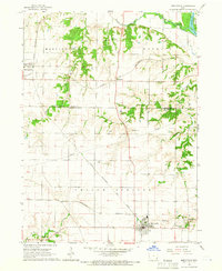
1965 Map of Mediapolis
USGS Topo · Published 1966About this map
Mediapolis serves as the primary hub of this eastern Iowa landscape, situated where the C. R. I. & P. and Chicago Burlington And Quincy railroads intersect. The map illustrates a well-developed agricultural and transportation corridor in the mid-1960s, with a dense network of country churches and burial grounds like Linn Grove Cem & Ch and Hazel Grove Cem anchoring the rural community. To the north, the terrain transitions into the Wapello and Morning Sun townships, where the Morning Sun settlement sits near the Chicago And North Western line. The eastern edge is defined by the Iowa River and Otter Creek, while smaller hamlets like Kossuth and Garland reflect the older settlement patterns of the Yellow Springs region. Resource extraction is evident through scattered Quarries and a Gravel Pit, supporting the local infrastructure and the busy rail lines that connect these prairie towns.
Find a feature on this map
31 named features on this map. Tap any name to fly to it.
Don’t see what you’re looking for? This feature index may not catch every label — zoom into the map to look around manually.
Map Details
Editions of this 1965 Mediapolis Map
This is the sole edition of this map. No revisions or reprints were ever made.
Other maps of this area

1934 · Burlington
USGS Topo · 1:48,000

1940 · Burlington
USGS Topo · 1:62,500

1946 · Wapello
USGS Topo · 1:62,500

1949 · Wapello
USGS Topo · 1:62,500

1953 · Toolesboro
USGS Topo · 1:24,000

1958 · Burlington
USGS Topo · 1:250,000

1958 · Davenport
USGS Topo · 1:250,000

1961 · Burlington
USGS Topo · 1:250,000

1961 · Davenport
USGS Topo · 1:250,000

1962 · Davenport
USGS Topo · 1:250,000