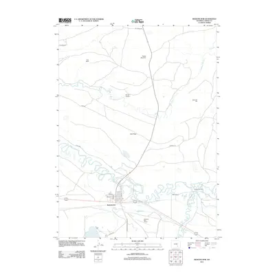
2012 Map of Medicine Bow
USGS Topo · Published 2012About this map
Medicine Bow serves as the focal point of this high plains landscape, situated at the confluence of regional travel routes and the winding Medicine Bow River. The town's grid, featuring streets like Pine St and Idaho St, reflects a settled outpost in a region primarily defined by expansive ranching and significant geological formations. To the east, the Little Medicine Bow River snakes through the terrain, passing near Two Bit Ranch and Robbers Roost Ranch, while the Vandiver Ditch indicates the historical importance of water management in this arid environment.
Find a feature on this map
26 named features on this map. Tap any name to fly to it.
Don’t see what you’re looking for? This feature index may not catch every label — zoom into the map to look around manually.
Map Details
Editions of this 2012 Medicine Bow Map
This is the sole edition of this map. No revisions or reprints were ever made.
Other maps of this area

1914 · Saddleback Hills
USGS Topo · 1:62,500

1915 · Como Ridge
USGS Topo · 1:48,000

1918 · Como Ridge
USGS Topo · 1:62,500

1921 · Saddleback Hills
USGS Topo · 1:62,500

1954 · Rawlins
USGS Topo · 1:250,000

1955 · Casper
USGS Topo · 1:250,000

1958 · Rawlins
USGS Topo · 1:250,000

1958 · Casper
USGS Topo · 1:250,000
1961 · Walker Draw SE
USGS Topo · 1:24,000

1961 · T B Ranch
USGS Topo · 1:24,000