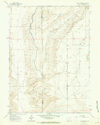
1961 Map of Walker Draw SE
USGS Topo · Published 1964About this map
The high plains of Albany Co and Carbon Co meet along a north-south boundary line where ranching and resource extraction define the local economy. The Little Medicine Bow River and Sheep Creek meander through the landscape, providing essential water sources for livestock operations in this arid region. Ranching infrastructure is clearly visible, centered on the Griffith Ranch and various outbuildings like the Corral located near the watercourses. The transportation network is anchored by Marshall Road, which cuts across the high ground of T B Flat. This 1961 field check also records industrial activity, such as a Gravel Pit near the road, highlighting the practical land use of the Wyoming interior during the early 1960s. The map’s fine red dashed lines indicate fence lines, offering a rare look at the exact boundaries of grazing lands and land tenure at mid-century.
Find a feature on this map
8 named features on this map. Tap any name to fly to it.
Don’t see what you’re looking for? This feature index may not catch every label — zoom into the map to look around manually.
Map Details
Editions of this 1961 Walker Draw SE Map
This is the sole edition of this map. No revisions or reprints were ever made.
Other maps of this area

1915 · Como Ridge
USGS Topo · 1:48,000

1918 · Como Ridge
USGS Topo · 1:62,500

1954 · Torrington
USGS Topo · 1:250,000

1954 · Cheyenne
USGS Topo · 1:250,000

1954 · Rawlins
USGS Topo · 1:250,000

1955 · Pine Tree Ridge
USGS Topo · 1:24,000

1955 · Casper
USGS Topo · 1:250,000

1958 · Rawlins
USGS Topo · 1:250,000

1958 · Casper
USGS Topo · 1:250,000

1958 · Cheyenne
USGS Topo · 1:250,000