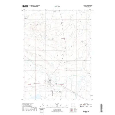
2017 Map of Medicine Bow
USGS Topo · Published 2017About this map
Medicine Bow sits at the southern edge of this high-plains landscape, where the confluence of the Medicine Bow River and Rock Creek creates a winding riparian network through the Carbon County desert. The settlement is defined by its grid of streets such as Spruce St and Maple St, situated north of the Medicine Bow Airport and the waters of E Allen Lake. This 2017 survey shows the enduring importance of ranching and water management in the region, evidenced by the Two Rivers Ranch and irrigation infrastructure like Vandiver Ditch. To the north, the terrain rises into significant geological features including the expansive Fossil Ridge and Flattop Mtn, while local history is preserved at the Trails End Cem. The map traces vital transportation corridors, from the arterial Marshall Rd to the curiously named Robbers Roost Rd, reflecting the area's frontier heritage.
Find a feature on this map
36 named features on this map. Tap any name to fly to it.
Don’t see what you’re looking for? This feature index may not catch every label — zoom into the map to look around manually.
Map Details
Editions of this 2017 Medicine Bow Map
This is the sole edition of this map. No revisions or reprints were ever made.
Other maps of this area

1914 · Saddleback Hills
USGS Topo · 1:62,500

1915 · Como Ridge
USGS Topo · 1:48,000

1918 · Como Ridge
USGS Topo · 1:62,500

1921 · Saddleback Hills
USGS Topo · 1:62,500

1954 · Rawlins
USGS Topo · 1:250,000

1955 · Casper
USGS Topo · 1:250,000

1958 · Rawlins
USGS Topo · 1:250,000

1958 · Casper
USGS Topo · 1:250,000
1961 · Walker Draw SE
USGS Topo · 1:24,000

1961 · T B Ranch
USGS Topo · 1:24,000