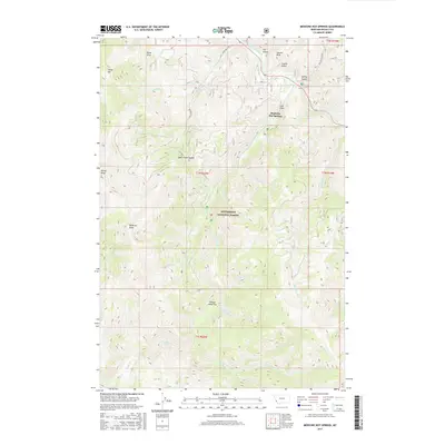
2017 Map of Medicine Hot Springs
USGS Topo · Published 2017About this map
Medicine Hot Springs marks the northern reaches of this mountain landscape, situated near the East Fork Bitterroot River as it winds through the Bitterroot National Forest. The geography is defined by sharp elevation shifts between Shook Mtn and Coyote Peak, with numerous drainages like Warm Springs Cr and Maynard Cr carving through the terrain. Evidence of high-country navigation is seen at Bear Creek Saddle and the lookout potential of Medicine Point. The area's land use is characterized by forest service access, including Laird Creek Rd and Sula Peak Rd 5727, which provide entry into the timbered slopes and open spaces like Sheeps Head Flat. These routes and named draws such as Lord Draw indicate a landscape long utilized for its thermal resources and timber, transitioning between the river valley and the higher peaks of the Bitterroot Range.
Find a feature on this map
40 named features on this map. Tap any name to fly to it.
Don’t see what you’re looking for? This feature index may not catch every label — zoom into the map to look around manually.
Map Details
Editions of this 2017 Medicine Hot Springs Map
This is the sole edition of this map. No revisions or reprints were ever made.
Other maps of this area

1955 · Dillon
USGS Topo · 1:250,000

1956 · Elk City
USGS Topo · 1:250,000

1957 · Dillon
USGS Topo · 1:250,000

1958 · Dillon
USGS Topo · 1:250,000

1960 · Elk City
USGS Topo · 1:250,000

1960 · Piquett Mountain
USGS Topo · 1:62,500

1962 · Dillon
USGS Topo · 1:250,000

1964 · Burnt Ridge
USGS Topo · 1:24,000
1964 · Robbins Gulch
USGS Topo · 1:24,000

1964 · Piquett Creek
USGS Topo · 1:24,000