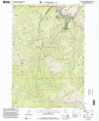
1998 Map of Medicine Hot Springs
USGS Topo · Published 2002About this map
Medicine Hot Springs serves as a focal point in this mountainous section of Ravalli County, situated along the East Fork Bitterroot River. This 1998 revision of earlier surveys depicts the land management patterns within the Bitterroot National Forest, where steep drainage systems like Laird Creek and Warm Springs Creek flow toward the river valley. The landscape is characterized by its recreational and lookout infrastructure, with several established campsites including Warm Springs Campground, Spring Gulch Campground, and Crazy Creek Campground. High-elevation landmarks such as Shook Mountain and the Medicine Point Lookout define the western ridges, providing a clear view of the complex hydrology of the region, from the Porcupine Creek headwaters in the south to the northern gulches near Jim Hill Rock.
Find a feature on this map
49 named features on this map. Tap any name to fly to it.
Don’t see what you’re looking for? This feature index may not catch every label — zoom into the map to look around manually.
Map Details
Editions of this 1998 Medicine Hot Springs Map
This is the sole edition of this map. No revisions or reprints were ever made.
Other maps of this area

1955 · Dillon
USGS Topo · 1:250,000

1956 · Elk City
USGS Topo · 1:250,000

1957 · Dillon
USGS Topo · 1:250,000

1958 · Dillon
USGS Topo · 1:250,000

1960 · Elk City
USGS Topo · 1:250,000

1960 · Piquett Mountain
USGS Topo · 1:62,500

1962 · Dillon
USGS Topo · 1:250,000

1964 · Burnt Ridge
USGS Topo · 1:24,000
1964 · Robbins Gulch
USGS Topo · 1:24,000

1964 · Piquett Creek
USGS Topo · 1:24,000